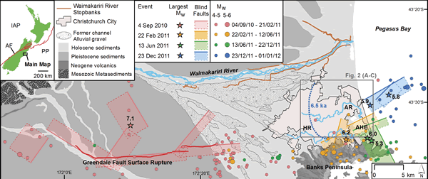
Figure 1.
Geologic and seismic context of Christchurch through the 2010–2011 Canterbury Earthquake Sequence (CES). Shown are inferred causative fault planes and associated largest moment magnitudes (MW) for events on 4 Sept. 2010, 22 Feb. 2011, 13 June 2011, and 23 Dec. 2011. Also shown are MW 4–6 epicenters in the months following each major event. The Greendale Fault surface rupture coincident with the 4 Sept. 2010 events is shown, after Quigley et al. (2012). Also shown are the Waimakariri River with adjacent stopbanks and former channel locations evidenced by alluvial gravels, Avon River (AR), Heathcote River (HR), and Avon-Heathcote Estuary (AHE). The blue dashed line is the 6.5-ka maximum inland extent of postglacial marine transgression, after Brown and Weeber (1992). Inset map shows location of the study region in New Zealand, the Alpine Fault (AF), and wider tectonic boundary (red lines) between the Indo-Australian plate (IAP) and Pacific plate (PP).