
Full Text View
GSA Today
![]()
Article, pp. 4-9 | Abstract | PDF (2.9MB)
Clinker geochronology, the first glacial maximum, and landscape evolution in the northern Rockies
| Table of Contents |
|---|
|
Search GoogleScholar for
Search GSA Today |
Abstract
Late Cenozoic erosion in the Powder River Basin of northern Wyoming and southern Montana has exhumed numerous coal beds to shallow depths where they burn naturally, forming erosion-resistant metamorphic rocks called clinker. Because most clinker forms tens of meters from the surface, its formation age records the timing and rate of exhumation through this depth, which can be used to constrain incision and lateral backwasting rates and the evolution of topographic relief. Zircon (U-Th)/He ages from ~100 distinct clinker units provide several insights into the geomorphic evolution of the region. Ages of in-situ clinker range from as old as 1.1 Ma to as young as 10 ka, but most formed in one of the last three interglacial periods, reflecting either changes in fluvial incision caused by glacial-interglacial cycles or other climatic effects on rates of natural coal burning. Most clinker older than ca. 200 ka is either detrital or >~200 m above local base level. Detrital clinker atop a broad strath terrace in the northern part of the basin provides a maximum age of 2.6 ± 0.2 Ma for terrace formation. This corresponds to the onset of major Northern Hemisphere glaciation interpreted from marine records, suggesting that the terrace formed by lateral erosion of the landscape as rivers were overwhelmed with sediment during the earliest Plio-Pleistocene glacial episode. The overall correlation of in-situ clinker ages with elevation above local base level can be interpreted with a simple model for shallow exhumation ages that requires increasing incision and topographic relief over at least the past ~1 Myr at rates of ~0.1–0.3 km/Myr, assuming typical clinker formation depths of 20–40 m.
*E-mail:
Manuscript received 19 Sept. 2010; accepted 24 Dec. 2010
DOI: 10.1130/G107A.1
INTRODUCTION
Landscapes lacking large spatial gradients in rock uplift rates are typically dominated by erosional landforms with relief of tens to hundreds of meters. The evolution of these features reflects changes in regional drainage patterns that in turn reflect climatic and tectonic forcing over large areas. Conventional low-temperature thermochronologic approaches are not well suited to understanding the evolution of erosional landforms at these scales because even low-temperature systems have closure depths much greater than the scales of the features themselves and therefore constrain denudation rates over much larger length scales and time scales. Conversely, cosmogenic nuclide approaches generally constrain denudation rates through depths at approximately meter-length scales, much smaller than those of the landforms. Quantitative understanding of how landscape features in the range of tens to hundreds of meters in scale evolve requires an approach that provides estimates of ages and rates of exhumation through commensurate depths.
In this paper, we summarize insights on landscape evolution of the Powder River Basin derived from formation ages of both in-situ and detrital clinker—metamorphic rock produced by the near-surface natural burning of coal. The approaches we use to interpret shallow exhumation ages provide several conclusions about the evolution of the region and highlight how similar types of constraints may be used to reveal patterns of relief change in erosional landscapes.
The Powder River Basin and Clinker
The Powder River Basin (Fig. 1) covers ~60,000 km2 of northeastern Wyoming and southeastern Montana near the northeast margin of the Rocky Mountain plateau, a region characterized by alternating mountain ranges with elevations up to 4.2 km above sea level and sedimentary basins with up to 11 km of Cenozoic structural depth. The Powder River Basin is both a Laramide syncline filled by Cretaceous and Paleogene sedimentary rocks and a modern drainage basin occupied by the Powder and Tongue Rivers draining to the north and the Belle Fourche and Cheyenne Rivers to the east. Most exposed rocks are fluvial sandstones and shales of the Paleocene Fort Union and Eocene Wasatch Formations, with coal beds up to ~60 m thick (Flores and Bader, 1999). Some of the thickest and most laterally continuous coals are associated with the Wyodak-Anderson coal zone, which, together with a few other Fort Union beds, made up ~42% of the 1.2 billion tons of coal mined in the U.S. in 2008 (U.S. Dept. of Energy, 2009).
Powder River Basin coals are relatively low-grade and volatile-rich, causing them to burn naturally when ignited by spontaneous combustion or wildfires. Coal beds only burn when exhumed to depths less than a few tens of meters from the surface, where they are adequately ventilated and above the water table. Burning results in locally intense heating of adjacent rock units (primarily those overlying the coal, due to advection of heat by escaping gases), producing a variety of baked and melted rock types collectively called clinker (Rogers, 1918; Cosca et al., 1989; Heffern and Coates, 2004; Heffern et al., 2007), which covers ~3700 km2 of the Powder River Basin.
Clinker tends to form erosion-resistant units that create escarpments and mesas, so its distribution dominates topography over much of the basin. Most of the southern Powder River Basin has broad rolling hills and flat-topped buttes capped by clinker, with relief typically <~200 m. However, large (~200 m) clinker-capped escarpments are present in some areas, such as the Rochelle Hills on the eastern side of the basin, formed by burning of the Wyodak-Anderson coal east of the major active mines (Fig. 1). In the central and northern parts of the basin, the Powder River, Tongue River, and Rosebud Creek and their tributaries have carved drainages containing subhorizontal flights of clinker-capped terraces and plateaus with relief in the hundreds of meters.
|
Physiography of the Powder River Basin and surroundings showing primary drainage patterns (blue), distribution of the Paleocene Fort Union and Eocene Wasatch Formations (green and brown, respectively), clinker outcrops (red), and approximate limit of the Powder River Basin as defined by the Cretaceous-Paleogene boundary. Filled circles are clinker sample locations with colors denoting groups listed to right. ECPR—East-central Powder River; RH—Rochelle Hills; WPR—Western Powder River. |
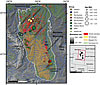 Figure 1
Like other Laramide basins, the Powder River Basin shows geomorphic and stratigraphic evidence for late Cenozoic incision and regional exhumation up to ~1 km (McMillan et al., 2006, and references therein), though the timing and cause of exhumation are debated (e.g., Riihimaki et al., 2007; Pelletier, 2009). Isolated erosional remnants of Oligocene units of the White River Formation are present near the center of the Powder River Basin, suggesting that much of the erosion was post-Oligocene, and other stratigraphic correlations and regional considerations suggest it was after 12–8 Ma (McMillan et al., 2006).
Dating Clinker and Shallow Exhumation
Quantitative interpretations of landscape evolution from clinker ages rely on an assumption of the depth of clinker formation, which is closely related to burn depth, or the depth at which coal burns to form clinker. Burning is primarily limited to depths where there is adequate air ventilation from the surface, although in some cases it may also be controlled by the water table. These factors may produce variation in local burn depths, but in general, observations of modern and historical burning and coal-clinker contacts suggest that burn depth is usually ~20–40 m (Shellenberger and Donner, 1979; Woessner et al., 1980; Coates and Naeser, 1984), which serves as a useful approximation for the typical maximum depth at which clinker is formed (see GSA Supplemental Data Repository 1 for further discussion).
1GSA supplemental data item 2011193, data tables and discussion of clinker formation depths, groundwater effects, alternative landscape models, detrital double dates, and basin-wide age patterns, is available online. You can also request a copy from GSA Today, P.O. Box 9140, Boulder, CO 80301-9140, USA; .
Our approach to dating clinker relies on resetting of thermochronologic ages of detrital zircon grains caused by the heat from burning coal. Zircon is abundant in many Powder River Basin sedimentary units and has relatively high U and Th concentrations that produce measureable quantities of fission tracks (FT) and radiogenic 4He over 104–106 yr timescales. Zircon FT ages in several places in the Powder River Basin show systematic age-distance trends in the Rochelle Hills, and relatively old clinker ages (2.2 ± 0.8 and 2.9 ± 0.9 Ma) were found at high elevations in the Little Wolf Mountains and in detrital clinker (3.8 ± 1.2 Ma) (Coates and Naeser, 1984; Heffern et al., 2007). However, zircon FT dating of clinker is limited by high uncertainty for samples with ages younger than ca. 1 Ma (typically 30%–60% [2σ]). Our work uses zircon (U-Th)/He (zircon He) dating of clinker, which has the main advantage of higher precision (reproducibility of single-grain analyses is generally <10% [2σ]). The vast majority of our single-grain ages display young ages (<1–3 Ma) and reproducibility consistent with full resetting during clinker formation. Cases of incomplete resetting, which are sometimes observed in thin clinker units, are easily distinguished by much older and irreproducible single-grain ages. Here we present 187 zircon (U-Th)/He dates from 92 distinct clinker units throughout the Powder River Basin (Tables S1 and S2 [see footnote 1]; ages from 55 of these units were previously reported in Riihimaki et al., 2009). Other new data reported here include 106 detrital zircon U/Pb ages and 15 double-dated He-Pb ages of detrital zircons (Tables S3 and S4 [see footnote 1]), as described in the following section.
Implications of Clinker Age Distributions
Dates from 86 in-situ clinker units range from <10 ka to 1.1 Ma (Fig. 2) and show a strongly clustered distribution, similar to that observed on a smaller dataset (n = 55) by Riihimaki et al. (2009). Most ages are clustered in three distinct peaks at ca. 10, 100, and 200 ka, with subsidiary peaks ca. 300 ka and between 450–550 ka. The exact significance of the apparently strong clustering in the last three interglacial periods and the hint of 100-k.y. periodicity is not known. It may reflect a basin fluvial response to regional glacial cycles (e.g., Hancock and Anderson, 2002). But, as noted by Riihimaki et al. (2009), the age distribution is better correlated with orbital eccentricity than with δ18O of benthic foraminifera or Pacific sea-surface temperatures. This is partly due to slight offsets in clinker age peaks and δ18O/SST maxima, but it also reflects a clear paucity of clinker ages ca. 400 ka (MIS 11), one of the largest and longest positive δ18O anomalies in the past 1 Myr (Fig. 2). The ~400 k.y. gap in clinker dates may reflect exceptional climatic or glacial conditions in this region at that time or possibly a different climatic influence more directly related to eccentricity.
|
Histogram and probability density (blue bars and trend) of zircon He ages from 86 in-situ clinker in the Powder River Basin. Also shown are δ18O of benthic foraminifera (Lisiecki and Raymo, 2005) and orbital eccentricity (Berger and Loutre, 1991) from 1.2 Ma to present. Clinker ages are clustered in peaks corresponding to the last three interglacials, two of which correspond to periods of high eccentricity (and maximum precessional variation in solar insolation). |
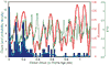 Figure 2
Detrital Clinker and Pliocene-Pleistocene Glaciation
In the northwestern Powder River Basin, a strath terrace forms a broad mesa ~300 m above surrounding fluvial channels and ~360 m above the nearby Yellowstone River (Fig. 1). This terrace and similar ones to the west were carved into Paleocene sandstone of the Fort Union Formation and are capped by ~2- to 20-m-thick alluvium containing detrital clinker clasts, as well as diverse lithologies, including volcanics likely derived from ranges hundreds of kilometers to the west (Colton et al., 1996). Detrital zircons in the alluvium matrix and underlying Paleocene sandstone show distinct U/Pb age spectra. Both contain 75–80 Ma zircons probably from the Idaho batholith and related rocks to the northwest. However, whereas the Paleocene sandstone shows a dominant 1.8 Ga peak, the young alluvium is distinguished by a very large Archean peak, likely from nearby Laramide ranges, as well as a significant 40–50 Ma peak, likely derived from Absarokan volcanics to the west (Table S3; Fig. S1 [see footnote 1]). Zircon Pb-He double-dating of zircons from the younger alluvium also shows that grains younger than ca. 85 Ma have indistinguishable crystallization and cooling ages, likely from volcanics or hypabyssal intrusions to the west (Fig. S1; Table S4 [see footnote 1]).
Detrital clinker in the strath-terrace alluvium yields zircon He dates ranging from 2.6 to 5.5 Ma (Table S2 [see footnote 1]). The oldest dates come from two clasts with a large date range (2.9–4.8 Ma and 4.7–5.5 Ma), consistent with partial resetting during clinker formation. The largest peak in this distribution, however, is 2.6–2.8 Ma, and two grains from one clast have indistinguishable ages of 2.65 ± 0.27 and 2.63 ± 0.19 Ma. Given that most in-place clinker in the Powder River Basin today is younger than ca. 200 ka, and assuming a similar source-to-alluvium lag time for the clinker in this deposit, we suggest that 2.6 ± 0.2 Ma is a reasonable estimate for the alluvium and strath terrace.
A variety of marine climate and ice-rafted debris records have been used to establish 2.7 Ma as the onset of major Northern Hemisphere glaciation (e.g., Prueher and Rea, 1998; Haug et al., 2005). Complementary records of continental chronologies have been hard to establish, however, partly because they have been obscured by multiple advance-retreat cycles. Thus far, the oldest recognized age for the first glacial maximum in North America is a cosmogenic burial age of 2.41 ± 0.14 Ma for a paleosol beneath a glacial till in Missouri (Balco et al., 2005). We suggest that this terrace and its capping alluvium represent outwash from one of the earliest phases of major Plio-Pleistocene alpine glaciation in the northern Rockies. The broad strath terrace and overlying thick alluvium containing far-travelled clasts are consistent with widespread lateral erosion and subsequent deposition by fluvial systems containing large quantities of sediment (as envisioned by Hancock and Anderson [2002] for younger terraces in Wyoming) derived from Absarokan glaciers, as well as nearby basinal clinker. This terrace is one of the most prominent erosional and Quaternary depositional surfaces in the region, and it appears to be correlated with others ~100 km to the west. We speculate that the earliest widespread glacial episode in a region that has not experienced prior glaciation might mobilize an extraordinarily large sediment load, producing strong lateral erosion and subsequent deposition. Downstream, the first major ice sheets may also produce the most significant changes in drainage configurations and transport capacity. Our interpretation of this terrace as the first major glaciation in the northern Rockies could be tested with further detrital geochronology, as well as cosmogenic burial dating, in this region.
In-Situ Clinker and Incision of the Powder River Basin
If the detrital-clinker–bearing terrace was formed by the Yellow-stone River that is now ~360 m below it, this implies a local average fluvial incision rate of 0.14 km/Myr since 2.6 Ma. This is similar to rates of 0.10–0.15 km/Myr calculated by Dethier (2001) for several Wyoming basins using the 0.64-Ma Lava Creek B ash bed. Spatial patterns of in-situ clinker dates have the potential to provide local estimates of erosion rates and relief changes over a longer time interval and over a much broader region, and are typically not minimum rates associated with deposition of dateable markers on preexisting surfaces.
Following conventional thermochronologic and cosmogenic approaches, to first order the ratio of depth and age of clinker formation is a local time-averaged erosion rate. Assuming a typical burn depth of 20–40 m provides an estimate of clinker formation depth. For formation depth of 30 m, the range of ages from 10 ka to 1.1 Ma implies time-averaged local erosion rates of 0.03–3 km/Myr. Long-term rates in any given location must be more uniform than this suggests, because maintaining these rate differences over million-year time scales would produce several kilometers of relief, much greater than the 102-m scale relief in the Powder River Basin. Because clinker formation itself produces relatively erosion-resistant lithologies, both erosion rates and topographic relief are likely to vary through time as clinker is produced, exhumed, and eroded away. This spatial and temporal variability in erosion should be evident in relationships between clinker age and topographic metrics.
At the broadest scale, most of the oldest in-situ clinker ages are near the periphery of the Powder River Basin (Fig. 1; Fig. S3 [see footnote 1]), reflecting the broad basinward dip of major coal beds, which are exhumed at progressively lower elevations toward the center of the basin. Young ages are common throughout the basin, however. Clinker ages do not show any discernable or statistically significant relationships with simple geomorphic indices such as local slope, elevation above sea level, or upstream drainage area. We have also examined correlations between clinker age and characteristics of each samples nearest stream, as defined by a channel with a drainage area >100 km2. Neither trunk-stream drainage area nor slope show significant correlations with age. In contrast, clinker ages show the best correlation with elevation above local base level (EABL), as defined by the elevation above the nearest stream segment with a >100 km2 drainage area.
The age of clinker (τ) now at the surface is the ratio of its formation depth (Zc) to the average rate at which it approached the surface after formation. In a landscape with changing relief, this rate depends on EABL (e.g., if relief is increasing, samples at low EABL approach the surface fastest). Here we model the relationship between τ and EABL by assuming separate rates of vertical incision (I) and lateral backwasting (L) (Fig. 3). Another rate for regionally uniform (vertical) erosion, eb, can also be included to simulate broad erosion causing exhumation but no change in relief. A similar model, which produces similar results, involves two different rates of purely vertical erosion at channel bottom and valley rim (see discussion in GSA Supplemental Data Repository [footnote 1]). Provided that rates are constant through time, both models lead to a simple relationship between clinker age τ and its vertical position normalized to valley depth Z/Zb, or the normalized EABL, that does not depend on either the initial morphology or absolute dimensions of the valley (Fig. 3). In all cases, τ is Zc/I at the valley bottom and Zc/L at the valley rim.
|
Model cartoon for evolution of a cross-valley profile used for predicting clinker ages, t, as a function of elevation above local base level (Z/Zb). L and I are rates of lateral backwasting at the valley rim, and incision at its base; eb is the spatially uniform vertical erosion rate; Zc is the formation depth of clinker. Black bands are unburned coal beds; red is clinker. |
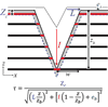 Figure 3
There are three general classes of age-EABL relationships. The first is one in which valley topography is either steady-state (I = L =0 ≠ eb) or approaches a self-similar form (I = L ≠ 0) (Fig. 4, top). If erosion rates are spatially uniform, topography is unchanged and τ is independent of EABL. Similarly, if I = L ≠ 0, the valley grows larger and approaches a constant depth-to-width ratio. Here t is slightly higher at intermediate elevations, because of the quadratic partitioning of erosion rates (this does not occur in the purely vertical erosion model). The second case is when L > I, resulting in valley widening, decreasing relief, and an inverse correlation between τ and EABL over most of the valley profile (Fig. 4, middle). The third case is when I > L, resulting in incision, increasing relief, and a positive correlation between τ and EABL (Fig. 4, bottom). This all assumes constant Zc. If Zc varies with EABL, as might be expected if groundwater exerts a stronger control than air ventilation on Zc, low-elevation ages will be younger (see GSA Supplemental Data Repository [footnote 1]).
|
Relationships between clinker age τ and normalized elevation above local base level (EABL) resulting from different combinations of rates of incision, I, lateral backwasting, L, and background erosion, eb, in the model valley profile shown in Fig. 3 and shown schematically as evolving profiles to right (horizontal black lines denote coal/clinker). All rates shown in left panel are in km/Myr; examples shown here assume clinker formation depth, Zc, of 30 m. In all left-hand panels, zero-elevation intercept is ratio of formation depth to erosion rate at valley bottom, and unity-elevation intercept is this ratio at valley rim. Upper panels: Cases of spatially uniform vertical erosion, eb, with zero incision, I, and lateral backwasting, L (steady-state topography), produce horizontal trends, with τ inversely proportional to eb, whereas cases in which I = L produce humped trends. Middle panels: Cases in which I < L, producing valley widening (decreasing topographic relief). Curve a: I = 0.05; L = 0.5; eb = 0 km/Myr. Curve b (just below curve a at low EABL): I = 0; L = 0.5; eb = 0.05 km/Myr. Lower panels: Cases in which I > L, producing valley deepening/incision (increasing topographic relief). Curve c: I = 0.5; L = 0.05; eb = 0 km/Myr. Curve d (just below curve c at high EABL): I = 0.5; L = 0.0; eb = 0.05 km/Myr. |
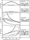 Figure 4
Figure 5 shows the actual Powder River Basin clinker ages as a function of normalized EABL. The overall distribution is most similar to model predictions for a valley profile in which incision is faster than lateral backwasting and relief is increasing (Fig. 4). The colored fields show predicted age-EABL correlations assuming clinker formation depths ranging from 20–40 m, incision rates of 0.1, 0.3, and 2 km/Myr, and a low lateral backwasting or broad-scale erosion rate (or combination of the two) of 0.025 km/Myr. Low lateral backwasting is required to explain the lack of in-situ clinker ages older than ca. 1.1 Ma. Assuming that all of the samples can be treated with a single set of regional erosion rates, the overall age distribution is similar to model predictions for a drainage network incising between 0.1 and 2 km/Myr. For clinker formation depths of 20–40 m, a model trend with I = 0.3 km/Myr provides a reasonable fit to the largest number of data. As shown by the fine dotted trends in Figure 5, if the clinker closure depth is more typically 10 m, incision rates as low as ~0.1 km/Myr may explain many of the data, as long as lateral backwasting and/or background erosion rates are nearly zero. In any case, whatever value is used for valley incision rate must be much greater than those for both lateral backwasting and background erosion. This requires increasing topographic relief.
|
Zircon He ages of in-situ clinker (colored circles) as a function of elevation above local base level (EABL). Blue, green, and red fields represent incision rates of 0.1, 0.3, and 2 km/Myr, with clinker formation depths, Zc, between 20 m (upper bounds) and 40 m (lower bounds). Bold colored lines are for clinker Zc of 30 m. These trends assume L = 0.025 km/Myr and eb = 0; swapping L and eb rates produces insignificant changes, showing that while it is possible to constrain the rate of the dominant erosive process (incision), it is not possible to say whether the relatively small contribution to erosion that makes most clinker ages at high elevation younger than 1.1 Ma is due to lateral backwasting or more uniform broad-scale erosion. Blue, green, and red thin dashed lines represent incision rates of 0.1, 0.3, and 2.0 km/Myr, and L = eb = 0 for low Zc of 10 m. Thicker green dashed line represents predictions of alternative simpler model described in the GSA Supplemental Data Repository (see text footnote 1), with I = 0.3 and R = 0.025 km/Myr. Although no single trend reproduces all the observations, there is an overall positive correlation between age and EABL that is consistent with incision rates of ~0.1–1 km/Myr, lateral backwasting or broad-scale erosion rates <~0.025 km/Myr, and increasing topographic relief since ca. 1.1 Ma. |
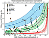 Figure 5
Several points at low EABL have ~10–20 ka ages that fall below the 0.1–0.3 km/Myr model trends that explain most of the data. This may reflect more rapid incision (at rates approaching ~1–2 km/Myr) of streams relatively recently (e.g., during the current interglacial). Similarly, abundant ca. 100-ka ages between ~60 and 240 m EABL may represent rapid incision during the last interglacial. The few points with ca. 500–600-ka ages at relatively low elevations above base level, as well as the age of 1.1 Ma in the Otter Creek group, may represent locations where lateral backwasting approaches vertical incision rates.
The fact that no single set of regional erosion rates can fit all the data from the Powder River Basin likely reflects variations in local clinker formation depths, differences in local erosion rates, and the limitations of using a simplified 2-D valley-profile model with distinct and constant erosion rates to model complex and evolving 3-D topography. Nonetheless, it is clear that at the scale of large drainage basins and the Powder River Basin as a whole, topographic relief must have increased over the past ~1 Myr at rates of ~0.1–0.3 km/Myr, though this may be episodic. We also note that the basic approach taken here for interpreting changes in relief may also be appropriate for other methods of dating shallow exhumation, including cosmogenic and pedogenic dating.
Based on the difference between reconstructed basin fill and modern topography, McMillan et al. (2006) calculated as much as ~1 km of Neogene incision in the Powder River Basin, though a more representative value over a larger area would appear to be ~0.8 km or less. At rates of ~0.3 km/Myr, 0.8 km of incision would require ~2.7 Myr, which is intriguingly similar to the 2.6 Ma age of the strath terrace that we interpret to be a result of the first major glaciation in the region, as well as the oldest in-situ clinker (2.2–2.9 Ma) found so far in the Powder River Basin (Heffern et al., 2007). Alternatively, using incision rates of ~0.1 km/Myr, consistent with a shallower estimate of clinker formation depth (Fig. 5), the longer-term average suggested by the 2.6 Ma strath terrace, and the highest regional incision rate of Dethier (2001), 0.8 km of incision would require ~8 Myr, similar to McMillan et al.s (2006) estimate for the initiation of regional incision.
Conclusions
Most clinker in the Powder River Basin formed during one of the last three interglacial periods, which may reflect more efficient incision of low-sediment rivers during interglacials or a more direct climatic control on clinker formation, possibly associated with eccentricity. However, much older clinker is found throughout the Powder River Basin, including as detrital clasts in alluvium atop a strath terrace ~360 m above the Yellowstone River, and as in-situ units typically >~200 m above local channels. Ages of detrital clinker suggest that the strath terrace and its capping alluvium are products of one of the, if not the, earliest major Plio-Pleistocene alpine glaciations in the region at 2.6 ± 0.2 Ma, which overwhelmed fluvial systems with sediment from distant mountain ranges, producing widespread lateral erosion of the landscape. The overall positive correlation between ages of in-situ clinker units and their elevation above local base level (which could be extended to other types of shallow exhumation ages) can be interpreted in the context of a simple model that constrains rates of incision, lateral backwasting, and evolution of topographic relief. Assuming typical clinker formation depths of 20–40 m, our data are most consistent with average incision and relief generation rates of ~0.1–0.3 km/Myr over the past ~1 Myr.
Acknowledgments
We appreciate analytical assistance from Stefan Nicolescu, Victor Valencia, and George Gehrels, and field assistance from Zoe Ruge, Camille Jones, Jessica Scheick, Kaia Davis, and Jason Whiteman. Thanks to Don Luse and staff at the Padlock Ranch for access. This work was supported by NSF grants EAR-0518818 to Reiners and EAR-0518754 to Riihimaki.
REFERENCES CITED
- Balco, G., Rovey, C.W., II, and Stone, J.O.H., 2005, The first glacial maximum in North America: Science, v. 307, p. 222.
- Berger, A., and Loutre, M.F., 1991, Insolation values for the climate of the last 10 million years: Quaternary Science Reviews, v. 10, p. 297–317.
- Coates, D.A., and Naeser, C.W., 1984, Map showing fission-track ages of clinker in the Rochelle Hills, southern Campbell and Weston Counties, Wyoming: U.S. Geological Survey Miscellaneous Investigations Map I-1462, scale: 1:50,000.
- Colton, R.B., Ellis, M.S., Heffern, E.L., Bierbach, P.R., Klockenbrink, J.L., and Grout, M.A., 1996, Photogeologic and reconnaissance geologic map of the Griffin Coulee and Griffin Coulee SW quadrangles, Rosebud and Treasure Counties, Montana: U.S. Geological Survey Miscellaneous Field Studies Map MF-2302, scale: 1:24,000.
- Cosca, M.A., Essene, E.J., Geissman, J.W., Simmons, W.B., and Coates, D.A., 1989, Pyrometamorphic rocks associated with naturally burned coal seams, Powder River Basin, Wyoming: The American Mineralogist, v. 74, p. 85–100.
- Dethier, D.P., 2001, Pleistocene incision rates in the western United States calibrated using Lava Creek B tephra: Geology, v. 29, p. 783–786.
- Flores, R.M., and Bader, L.R., 1999, Fort Union coal in the Powder River Basin, Wyoming and Montana: A synthesis: U.S. Geological Survey Professional Paper 1625-A, Chapter PS, 49 p., CD-ROM disks 1 and 2.
- Hancock, G.S., and Anderson, R.S., 2002, Numerical modeling of fluvial strath-terrace formation in response to oscillating climate: GSA Bulletin, v. 114, p. 1131–1142.
- Haug, G.H., Ganopolski, A., Sigman, D.M., Rosell-Mele, A., Swann, G.E.A., Tidedmann, R., Jaccard, S.L., Bollmann, J., Maslin, M.A., Leng, M.J., and Eglinton, G., 2005, North Pacific seasonality and the glaciation of North America 2.7 million years ago: Nature, v. 433, p. 821–825.
- Heffern, E.L., and Coates, D.A., 2004, Geologic history of natural coal-bed fires, Powder River basin, USA: International Journal of Coal Geology, v. 59, p. 25–47.
- Heffern, E.L., Reiners, P.W., Naeser, C.W., and Coates, D.A., 2007, Geochronology of clinker and implications for evolution of the Powder River Basin landscape, Wyoming and Montana, in Stracher, G.B., ed., Geology of Coal Fires: Case Studies from Around the World: Geological Society of America Reviews in Engineering Geology 18, p. 155–175.
- Lisiecki, L.E., and Raymo, M.E., 2005, A Pliocene-Pleistocene stack of 57 globally distributed benthic δ18O records: Paleoceanography, v. 20, doi: 10.1029/2004PA001071.
- McMillan, M.E., Heller, P.L., and Wing, S.L., 2006, History and causes of post-Laramide relief in the Rocky Mountain orogenic plateau: GSA Bulletin, v. 118, p. 393–405, doi: 10.1130/B25712.1.
- Pelletier, J.D., 2009, The impact of snowmelt on the late Cenozoic landscape of the southern Rocky Mountains, USA: GSA Today, v. 19, no. 7, p. 4–11.
- Prueher, L.M., and Rea, D.K., 1998, Rapid onset of glacial conditions in the subarctic North Pacific region at 2.67 Ma: Clues to causality: Geology, v. 26, p. 1027–1030.
- Riihimaki, C.A., Anderson, R.S., and Safran, E.B., 2007, Impact of rock uplift on rates of late Cenozoic Rocky Mountain river incision: Journal of Geophysical Research, v. 112, F03S02, doi: 10.1029/2006JF000557.
- Riihimaki, C.A., Reiners, P.W., and Heffern, E.L., 2009, Climate control on Quaternary coal fires and landscape evolution, Powder River basin, Wyoming and Montana: Geology, v. 37, p. 255–258.
- Rogers, G.S., 1918, Baked shale and slag formed by the burning of coal beds: U.S. Geological Survey Professional Paper 108-A, p. 1–10.
- Shellenberger, F.H., and Donner, D.L., 1979, Controlling fires in unmined coal deposits and abandoned coal mines in the western United States and Alaska: U.S. Bureau of Mines Progress Report 10047, 150 p.
- U.S. Dept. of Energy, 2009, Energy Information Administration Annual Coal Report 2008: http://www.eia.doe.gov/cneaf/coal/page/acr/acr.pdf (last accessed 3 Apr. 2011).
- Woessner, W.W., Osborne, T.J., Heffern, E.L., Andrews, C., Whiteman, J., Spotted Elk, W., and Morales-Brink, D., 1980, Hydrologic impacts from potential coal strip mining—Northern Cheyenne Reservation, v. 1, Technical Report NTIS-PB81155061, EPA-600-7-81-004a, Industrial Environmental Research Laboratory, Office of Research and Development: Cincinnati, Ohio, U.S. Environmental Protection Agency, 321 p.