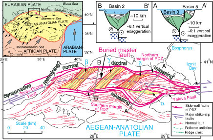
Figure 1. Structural map showing margins of principal deformation zone (PDZ), major strike-slip faults (half arrows), and normal faults with ticks on hanging wall. Areas a, b, g, and d are major ridges. Structural features are taken directly from interpreted seismic profiles along closely spaced survey tracks (Fig. 2E), so this figure is just like the field map of a land geologist. The only interpreted features are buried, dashed trace of dextral North Anatolian transform fault (NATF) and inferred zones of compression (restraining bends) and extension (releasing bends). Upper left inset is simplified tectonic map of eastern Mediterranean region, showing sense of plate motion (large gray-headed arrows) and global positioning system (GPS) horizontal velocities of Aegean-Anatolian plate (from Reilinger et al., 2000) relative to a fixed Eurasian plate (thin black arrows scaled in length to GPS velocities in mm/yr). Half arrows indicate transform or strike-slip faults. Cross sections A–A' and B–B' show our perception of architecture of elongate negative flower structure where it has central anticlinal swell and step-out basin perched on edge of principal deformation zone (A–A'; compare Fig. 4A), and where it encloses symmetrical graben (B–B'; compare Fig. 4B). Green substratum in cross sections represents older deposits beneath Pliocene to Quaternary basin fill.