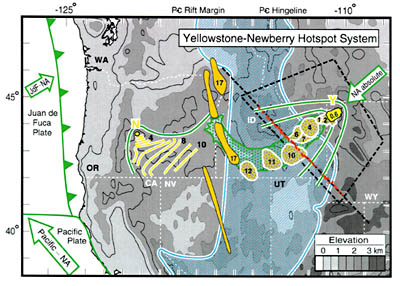
Figure 1. Volcanic-tectonic setting of Yellowstone-Newberry hotspot system. Volcanic elements are shown in gold and yellow (current locations of Yellowstone [Y] and Newberry [N] calderas in yellow), and tectonic elements are shown in blue (for older features) and green (younger features). Arrows indicate North America (NA) absolute motion and oceanic plate relative motions. Transform (solid) and subduction (toothed) plate boundaries are shown near western coastline. This hotspot system initiated 17 Ma from central Nevada riftÐSteens MountainsÐColumbia River flood basalt fissures (solid gold areas, from Christiansen and Yeats, 1992) located near the latest Precambrian rift margin of North America (western blue line, from Burchfiel et al., 1992). After ~5 m.y. delay, magmatism propagated west-northwest to Newberry (gold lines show initial rhyolitic volcanism in 1 m.y. increments, from MacLeod et al., 1976), constructing the High Lava Plains (north and west margins shown with green line in Oregon), and east-northeast to Yellowstone (major rhyolitic caldera centers shown in gold pattern with ages in m.y.; from Pierce and Morgan, 1992). Yellowstone propagation was rapid across Paleozoic passive margin (blue ruled area), and stalled near Precambrian hingeline (eastern blue line, from Burchfiel et al., 1992). Yellowstone swell occupies Anders et al.'s (1989) "tectonic parabola" (shown with parabolic-shaped green lines) and depressed Snake River Plain (green pattern). Red dots show seismometer locations. Black dashed lines indicate cross section and map area shown in Figure 3.