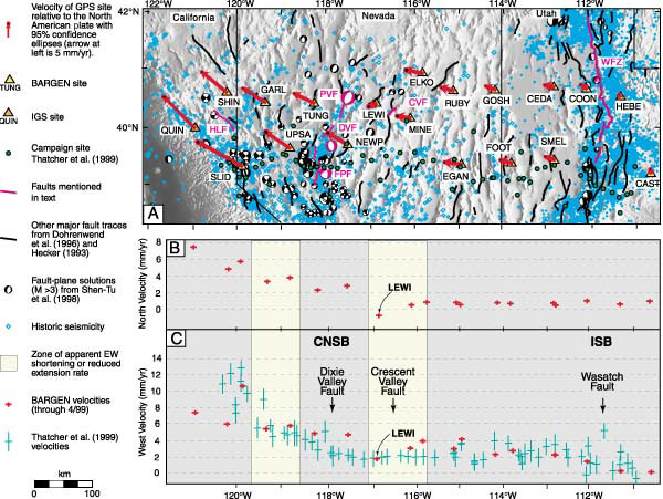
Figure 2. A: Shaded relief map of a transect across northern Great Basin showing seismicity, traces of selected fault zones, and GPS velocity vectors (with 95% confidence ellipses) from continuous sites from 1996 to 1999 (Bennett et al., 1999). Historic seismicity from Council of the National Seismic System. Historic earthquakes in central Nevada seismic belt (CNSB): DVF—Dixie Valley (1954); FPF—Fairview Peak (1954); PVF—Pleasant Valley (1915). Faults (in pink): CVF—Crescent Valley fault; DVF—Dixie Valley fault; FPF—Fairview Peak fault; HLF—Honey Lake fault; PVF—Pleasant Valley fault; WFZ—Wasatch fault Zone. IGS—International GPS service. ISB—Intermountain seismic belt. B: North components of velocity as a function of longitude, with 1 s error bars. C: West components of velocity as a function of longitude, from BARGEN continuous GPS data (red, from Bennett et al., 1999; periodically updated velocity solutions available at BARGEN [September 2000]) and campaign GPS data (green, from Thatcher et al., 1999).