Dynamics of Plate Boundary Fault Systems from Basin and Range
Geodetic Network (BARGEN) and Geologic Data
Brian Wernicke, Anke M. Friedrich,
Nathan A. Niemi, Division of Geological and Planetary Sciences, California Institute
of Technology, Pasadena, CA 91125, USA
Richard A. Bennett, James L. Davis, Harvard-Smithsonian Center for Astrophysics,
60 Garden Street, Cambridge, MA 02138, USA
ABSTRACT
Continuously recorded Global Positioning System (GPS) data from the northern Basin and Range suggest that contemporary deformation is quite slow and broadly distributed, rather than being concentrated in the relatively narrow zones of historical earthquakes. Surprisingly, however, in north-central Nevada, the data indicate rapid, range-normal crustal shortening at a rate of 2–3 mm/yr in an area where the geology indicates crustal extension via Holocene normal faulting. A possible explanation for the conflicting geodetic and geologic data is that the region of shortening represents the contractile side of a slowly east-propagating deformation pulse generated by the 1915 Pleasant Valley and 1954 Dixie Valley and Fairview Peak earthquakes. Such pulses, which are transient effects not recorded by faulting, are predicted by a broad class of physical models, but have only been observed within a few years after very large earthquakes, when the signal is much larger than the long-term deformation rate. The Basin and Range, and similar areas with a combination of low long-term deformation rates and large earthquakes, may therefore have the best potential by combining modern geologic and geodetic data to elucidate fault system behavior, in particular how transient effects from an earthquake on one fault may influence patterns of stress and seismic strain release on others. These types of data are essential in developing realistic models of seismic hazard, and in linking short–time scale observations with longer term geologic processes.
INTRODUCTION
The relative motion of rock masses is the prime observable for competing the-ories of earth deformation, at time scales ranging from a fraction of a second (e.g., seismic waves) to hundreds of millions of years (breakup and aggregation of supercontinents). Traditionally, the study of these kinematic phenomena have been segregated by frequency band or time scale, each requiring different approaches, such as seismology, geodesy, structural geology, and isotope geochemistry. Major progress is likely to transcend temporal and disciplinary boundaries, challenging us to bridge them with coordinated, broadband research.
In this paper, we describe a prototype of such an effort focused on the northern Basin and Range province of western North America. The area lies between the Sierra Nevada–Great Valley block to the east and the Colorado Plateau to the west, and is characterized by north-trending mountain ranges and basins of curiously uniform size and spacing (Fig. 1). Ranges rise ~1500 m above adjacent basins, and are spaced about 30 km apart. This part of the Basin and Range reaches a maximum width of 750 km at latitude 40°N, and includes some 20–25 basin-range pairs. The ranges began forming between 10 and 15 Ma as the Sierra Nevada–Great Valley block moved westward relative to the interior, first at rates near 20 mm/yr almost due west (Wernicke and Snow, 1998), then slowing to the current overall rate near 12 mm/yr northwest (Hearn and Humphreys, 1998; Bennett et al., 1999; Thatcher et al., 1999; Dixon et al., 2000). Total displacement of the block since 16 Ma is ~250 km (Wernicke and Snow, 1998). Most of the ranges are delimited on one side by a major normal fault with significant Quaternary slip (Dohrenwend et al., 1996).
The uniformity in size and spacing of the ranges implies relatively uniform
crustal strain, which is distortion, expressed as the amount of tectonic displacement
per unit distance in a particular direction, designated as strains (str), microstrains
(µstr, 10–6 str) or nanostrains (nstr, 10–9 str).
For example, 1 nstr represents the elongation of a 1-m-long rod by 1 nm, or a
1000-km-long rod by 1 mm. Between repeated earthquakes, elastic strain buildup
in the upper part of the crust increases the load or stress on faults (interseismic
strain accumulation) until an earthquake occurs, when the stress drops and the
elastic strain is released by fault slip (coseismic strain release). At latitude
40°N (Fig.
2A) in the Basin and Range, in contrast to the apparent uniformity of crustal
strain, coseismic strain release over the last few hundred years has been strongly
concentrated in the Intermountain seismic belt on the east side of the province
(Wasatch fault zone), the central Nevada seismic belt near the west side of the
province (Fairview Peak, Dixie Valley, and Pleasant Valley fault zones), and on
faults along the western margin (Honey Lake fault zone and related faults; Fig.
2A). The most recent strong (M > 6.5) earthquakes along the 40°N transect
occurred in 1915 on the Pleasant Valley fault (Wallace, 1977) and in 1954 on the
Dixie Valley, Fairview Peak, and related faults (Caskey et al., 1996; Fig.
2A). Along the Wasatch fault zone, the most recent strain release via earthquakes
occurred on fault segments near latitude 40°N ~1500 yr B.P. (Machette
et al., 1992). Outside of these areas, fewer than half of the range-bounding faults
have Holocene slip, and many of them may not have significant Late Pleistocene
(<130 000 yr B.P.) slip (Wallace, 1987; Dohrenwend et al., 1996).
The contrast in behavior at different time scales raises the question of whether the accumulation of extensional strain in the province is spatially uniform or is mostly or completely concentrated within the seismically active belts. At one extreme, strain accumulation on all faults in the system occurs simultaneously and at a very low rate, and hence contemporary deformation measurements using GPS would be of little use in distinguishing which fault is most likely to fail next. At another extreme, strain accumulation on a given fault in the system would occur rapidly over a short period of time, separated by a long interval where it occurs on other faults. In this case, high contemporary strain rates in any given area would indicate seismic hazard, and the pattern of strain accumulation in time and space would be relatively complex.
Here, we summarize aspects of recent geological and geodetic investigations across the province bearing on the question of continuous versus discrete strain accumulation and release on intraplate fault systems, and on the general potential of such broadband studies of earth deformation for advancing tectonic research.
BASIN AND RANGE GEODETIC NETWORK (BARGEN)
To investigate the active tectonics of the province, we established a 50-station
network of continuously operating GPS stations across the northern and central
Basin and Range, known as the Basin
and Range Geodetic Network, or BARGEN (Fig.
1; BARGEN [September
2000]). In order to develop tectonically meaningful data in a short period of
recording (a few years), the effects of local ground movement contaminating the
signal (Wyatt, 1982) had to be minimized, and thus each BARGEN site includes a
high-stability geodetic monument (Langbein et al., 1995; Fig.
3). BARGEN GPS data are downloaded daily via telemetered relays and processed
(see Bennett et al., 1998, 1999, and BARGEN
[September 2000] for details). The ultimate result of processing data over a particular
time interval is a geodetic solution, which includes the north, east, and vertical
components of position and velocity. The solution may be presented as a table
of velocity components, maps of horizontal velocity vectors (velocity fields as
in Fig.
2A), plots of velocity components with respect to site position, the slopes
of which are velocity gradients (as in Figs.
2B and 2C), and plots of the position of individual components versus time
(time series as in Fig.
4). Velocity gradients, or velocity change per unit distance in a given direction,
are also strain rates, reported below in units of nanostrains per year (nstr/yr),
which is equivalent to 3 x 10-17 strains per second.
Prior to space-based techniques such as GPS, geodetic surveys required line-of-sight laser interferometer measurements, from mountain peak to mountain peak, through the optically noisy lower troposphere. This generally required transport of heavy equipment by aircraft for each survey, and flights along baselines to correct for atmospheric conditions. Repeated over a span of 10–20 years, these expensive and laborious surveys were able to provide strain rate measurements accurate to as little as ±10–20 nstr/yr, but each measurement represented only an average or bulk strain rate of many sites, over areas at most a few tens of kilometers wide, without spatial referencing to other networks or sites (e.g., Savage et al., 1995). Using these networks, inferred velocities were accurate to within 1–2 mm/yr, with gradual improvement only possible after decades of repeated surveys. As illustrated below, GPS geodetic solutions using continuously acquired data yield directly the velocity of each site in a global reference frame (i.e., velocity fields), accurate to within as little as ±0.2–0.5 mm/yr, and large-scale strain rates to within ±2 nstr/yr, in just a few years of monitoring. The method is comparatively inexpensive because sites need not be on mountain peaks, require little visitation once installed, and yield results in years rather than decades. Obviously, this new capability opens a vast horizon for observing fault systems, especially at scales larger than a few tens of kilometers and strain rates of 10 nstr/yr or less, as required for study of most intraplate fault systems and strain transients.
The velocity field, relative to the North American plate, of the first 18 BARGEN
sites installed (in 1996 and 1997), shows monotonically increasing west to northwest
velocity, from near 0 mm/yr on the east side of the province up to 12 mm/yr on
the west, becoming more northerly from east to west (Fig.
2A; see BARGEN
[September 2000] for a data table). The west components of motion increase monotonically
westward, indicating broadly distributed extensional strain at a rate of ~10
nstr/yr. By comparison, rates adjacent to the San Andreas fault system are as
much as 200–300 nstr/yr (e.g., Bennett et al., 1999), or 20–30 times
Basin and Range rates. The north components of velocity are near zero across the
eastern half of the province, but from central Nevada to the Sierra Nevada increase
rapidly westward to values near 7 mm/yr.
One site in the network (LEWI, Fig.
2A), however, lies well off these trends in both north and west components,
raising the question of relatively large systematic error in continuous GPS velocities,
at least for certain sites. Further, the initial results of three campaign-mode
GPS surveys (in 1992, 1996, and 1998) near latitude 40°N, which involved
a larger number of stations (Figs. 2A and 2C) but very sparse temporal sampling,
were interpreted to indicate high strain rates along the seismically active margins
of the province, and low strain rates in the relatively aseismic interior (Thatcher
et al., 1999). This contrast in tectonic interpretations is illustrated by comparison
of the west components of velocity for the two network solutions (Fig.
2C).
Thus, evaluating error sources in both continuous and campaign modes of surveying
is crucial to resolving the apparent difference. For our ~2.5 yr solution,
formal errors (1 s) in site velocity (either between sites or relative to a North
American reference frame) are in the 0.1–0.2 mm/yr range (Davis et al., 1999).
The formal errors, which account for uncertainties in phase measurement, timing
(clock error), satellite position, atmospheric distortion, and other effects,
may underestimate the true uncertainty or accuracy of the solution, which could
arise from factors such as monument instability. The formal errors are reasonable
estimates, however, because the scatter of the west velocities about a regression
line is only about 0.5 mm/yr. If the actual errors were significantly higher,
then the scatter of the data would be significantly greater than this value (Davis
et al., 1999). This value is therefore an upper bound, because a significant component
of the scatter may of course be due to real variations from linearity in the deformation
field, rather than error. For the 11 sites in the eastern part of the network
where north velocities are near zero, the scatter about a line of zero slope is
only ~0.3 mm/yr (Fig.
2B; Davis et al., 1999). Assuming a model of no differential north-south motion
for the eastern part of the network (a reasonable inference based on the geology),
this value is near the formal error in velocity. In sum, we estimate our velocity
error at 0.5 mm/yr based on 2.0–2.5 years of data, noting there is a reasonable
possibility that errors may be as low as 0.1–0.2 mm/yr (Davis et al., 1999).
In contrast, a campaign-mode effort in the same region, measuring six years of
deformation, only resolves the velocity of any particular site or group of sites
to within 1–2 mm/yr (Fig.
2C).
INTERPRETING THE ANOMALOUS MOTION OF SITE LEWI
The velocity of site LEWI is 2–3 mm/yr below the west velocities of its
two neighboring sites MINE and TUNG (Fig.
2A), defining a region of crust that is shortening at a rate of about 2.0
mm/yr, or 25 nstr/yr for this 80-km-long baseline. This value is at least four
times our estimate of error in velocity. But is it accurate, and is there a reasonable
explanation for it?
A time series of the relative position of LEWI and MINE has a well-defined
negative slope, indicating east-west shortening (Fig.
4A), in contrast with other time series in the network that have positive
slopes, indicating east-west elongation (e.g., EGAN relative to FOOT, Fig. 4B).
Spectral analysis of LEWI's position did not reveal any characteristics, such
as overall scatter, low-frequency noise or annual fluctuations, that are greater
than those for other sites in the network (Davis et al., 1999), and so the only
basis for questioning its accuracy is the fact that its velocity is anomalous.
The overall northwest convergence direction between LEWI and MINE (obtained by
subtracting their respective horizontal velocity vectors) is normal to the trace
of the Crescent Valley fault (Fig.
2A), an archetypal range-bounding normal fault with Holocene scarp heights
as high as 5 m (A. Friedrich and J. Lee, oral commun., 2000). At 2 mm/yr, the
shortening could not continue for more than a few thousand years without contractional
strain release (thrust faulting), suggesting the shortening is a transient state
of strain, where the crust in the Crescent Valley area is still in a state of
deviatoric tension, but with the magnitude of differential stress decreasing with
time as a transient pulse or wave of contraction counteracts the regional stress
field. Thus at present, despite the ominous appearance of the fault, the seismic
hazard would appear to be decreasing with time.
A simple explanation for such a transient phenomenon is the response of viscous layers in the deep crust and upper mantle to an earthquake or earthquakes. In such a model, the sudden release of elastic strain energy in the upper, brittle portion of the crust perturbs or excites the deep crust and upper mantle stress field. Although these layers are elastic on a short time scale, they may also behave viscously at longer time scales, in response to the stresses imposed by faulting. Such viscoelastic behavior is short-lived (decades to centuries) and may be opposite in sign to regional strain accumulation patterns, depending on time, position, and the mechanical properties of the crust. In the case of a normal fault earthquake, upper crustal blocks on either side of the fault snap back (shorten) in response to coseismic extension, much like the breaking of a stretched rubber band. The brittle crust thereby imposes a shearing traction on the viscous substrate, which decreases away from the fault. The shearing traction, at first concentrated near the fault, spreads outward as the substrate slowly responds to relieve stress. Thus after the earthquake, the region affected by coseismic shortening slowly extends, and the region just outside of it begins to shorten. Although such a strain pattern has not previously been observed adjacent to a large normal-fault earthquake, it was observed in GPS surveys between 1987 and 1992 across the Northern Volcanic Zone in Iceland, which experienced a rapid episode of dike injection in 1975 (Foulger et al., 1992, 1996).
The system may be understood quantitatively, to first order, by a physical
model where an instantaneous displacement is applied to an elastic layer overlying
a viscous layer (Fig.
5A; Bott and Dean, 1973). The elastic layer shortens during an earthquake,
imparting a top-outward horizontal traction on the viscous substrate, such that
the traction and horizontal displacement u decays according to the diffusion
equation, or

where x is the horizontal distance, t is time, and k is the diffusivity.
The horizontal surface velocity is simply the time derivative of the error-function
solution to the diffusion equation, or
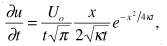
where Uo is ½ the total horizontal dilation during the
earthquake, and k = Ebh/n
(Foulger et al., 1992; parameters defined in Fig.
5A). The model predicts rapid (relative to interseismic values) postseismic
extension adjacent to the fault (the positive velocity versus distance slopes,
Figs. 5B and 5C), and shortening in a band outward of it (the negative slopes).
In this particular model (which is by no means unique), the velocity outward from
the fault zone at x = 60 km is 3–4 mm/yr 100 years after the earthquake
(heavy curve in Fig.
5C), in good agreement with relative eastward velocity of LEWI with respect
to MINE and TUNG. To the west of the central Nevada seismic belt, we note that
although a region of rapid shortening is not apparent, west velocities decrease
slightly between sites TUNG and GARL, contrary to the regional, comparatively
rapid, velocity gradients west of the central Nevada seismic belt observed in
both campaign and BARGEN data.
The model in Figure 5 may provide a reasonable first-order estimate of these effects, but it ignores many potentially important considerations, such as truly viscoelastic behavior of the substrate (in this model, it is purely viscous), and three-dimensional effects such as right-lateral shear and the finite length of fault segments. Nonetheless, it seems clear that if viscoelastic phenomena are indeed an important component of the geodetic signal, they may also provide an explanation for many of the smaller local anomalies in velocity, such as higher local strain rates along the Wasatch fault zone (e.g., baseline HEBE-COON) and in the Reno-Tahoe area (e.g., baseline UPSA-SLID).
Strain accumulation may therefore be relatively homogeneous across the region, with higher rates in seismogenic zones due to viscoelastic effects, rather than higher strain accumulation rates. We note that the long-term slip rates on Basin and Range faults (of order 30–300 k.y.) do not appear to be in excess of 0.5 mm/yr (17 nstr/yr on a 30 km baseline), even within the active seismic zones (e.g., Zreda and Noller, 1998; de Polo, 1998; Machette et al., 1992; Caskey et al., 1996; Friedrich et al., 2000), which is about an order of magnitude less than would be required if all the strain accumulation in the province were focused within one or two seismic belts at those time scales (say, 5 mm/yr on a 50 km baseline, or 100 nstr/yr). So it is possible, if not probable, that the geodetic signal, like the pattern of ranges and basins, speaks to relatively homogeneous strain accumulation across the province (linear velocity versus distance plots), perturbed by comparatively large viscoelastic effects of the most recent earthquakes.
CONCLUSIONS
These results, while preliminary, nonetheless demonstrate the power of combining modern geodetic and geologic data, especially in areas where transient signals are easily distinguishable from interseismic strain accumulation. In areas where strain accumulation is rapid (100s of nstr/yr), as along the San Andreas fault or in the Ventura or Los Angeles basin areas, postseismic transient strain rates are (1) of the same order or smaller than strain accumulation rates, (2) occupy a large fraction of the total interseismic period, and (3) are strongly overprinted by strain accumulation signatures of major plate boundary faults (e.g., Hager et al., 1999). However, in areas such as the Basin and Range, transient strain rates may be much easier to characterize because they are of the same magnitude as in rapidly straining areas (i.e., earthquakes in the Basin and Range are about the same size as those in the Los Angeles basin), but are an order of magnitude larger than the average strain accumulation rate, persist for only a small fraction of the interseismic cycle, and are relatively uncontaminated by strain accumulation signals from neighboring faults. A combination of paleoseismology, continuous GPS, and viscoelastic modeling in the Basin and Range may therefore offer the best potential to advance our understanding of the dynamics of fault systems, in ways that would be difficult or impossible in areas that are the traditional focus of geodetic studies, where biases from neighboring fault zones and large corrections for interseismic strain rates obscure patterns of fault interaction.
ACKNOWLEDGMENTS
BARGEN research is conducted under the auspices of the National Science Foundation's Continental Dynamics Program, the U.S. Department of Energy's Yucca Mountain Project, and NASA's Solid Earth and Hazards Program, with design and maintenance assistance from the University Navstar Consortium (UNAVCO) Facility in Boulder, Colorado, the University of Nevada, Reno, and the University of Utah. We thank Gene Humphreys, Wayne Thatcher, and Karl Karlstrom for many useful suggestions on the manuscript.
REFERENCES CITED
Bennett, R.A., Wernicke, B.P., and Davis, J.L., 1998, Continuous GPS measurements of contemporary deformation across the northern Basin and Range: Geophysical Research Letters, v. 25, p. 563–566.
Bennett, R.A., Davis, J.L., and Wernicke, B.P., 1999, Present-day pattern of Cordilleran deformation in the western United States: Geology, v. 27, p. 371–374.
Bott, M.H.P., and Dean, D.S., 1973, Stress diffusion from plate boundaries: Nature, v. 243, p. 339–341.
Caskey, S.J., Wesnousky, S.G., Zhang, P., and Slemmons, D.B., 1996, Surface faulting of the 1954 Fairview Peak (Ms 7.2) and Dixie Valley (Ms 6.8) earthquakes, central Nevada: Bulletin of the Seismological Society of America, v. 86, p. 761–787.
Davis, J.L., Bennett, R.A., and Wernicke, B.P., 1999, Accuracy of velocities from BARGEN continuous GPS data 1996–1999: Eos (Transactions, American Geophysical Union), v. 80, p. F269.
de Polo, C.M., 1998, A reconnaissance technique for estimating the slip rates of normal-slip faults in the Great Basin, and application to faults in Nevada, U.S.A. [Ph.D. dissert.]: Reno, University of Nevada, 381 p.
Dixon, T.H., Miller, M., Farina, F., Wang, H., and Johnson, D., 2000, Present-day motion of the Sierra Nevada block and some tectonic implications for the Basin and Range province, North American Cordillera: Tectonics, v. 19, p. 1–24.
Dohrenwend, J.C., Schell, B.A., Menges, C.M., Moring, B.C., and
McKittrick, M.A., 1996, Reconnaissance photogeologic map of young (Quaternary
and late Tertiary) faults in Nevada, in Singer, D.A., ed., An analysis
of Nevada's metal-bearing mineral resources: Nevada Bureau of Mines and Geology
Open-File Report 96-2.
Foulger, G.R., Hofton, M.A., and Voelksen, C., 1996, Viscoelastic modelling of post-diking anelastic deformation in North Iceland: A new epoch of GPS measurements: Eos (Transactions, American Geophysical Union), v. 77, p. 149.
Foulger, G.R., Jahn, C.H., Seeber, G., Einarsson, P., Julian, B.R., and Heki, K., 1992, Post-rifting stress relaxation at the divergent plate boundary in northeast Iceland: Nature, v. 358, p. 488–490.
Friedrich, A.M., Wernicke, B.P., Niemi, N.A., and Bennett, R.A., 2000, Rates of extensional strain accumulation in the eastern Great Basin, western United States: constraints from continuous GPS data (BARGEN) and paleoseismology: Eos (Transactions, American Geophysical Union), v. 81, p. S412.
Hager, B.H., Lyzenga, G.A., Donnellan, A., and Dong, D., 1999, Reconciling rapid strain accumulation with deep seismogenic fault planes in the Ventura Basin, California: Journal of Geophysical Research, v. 104, p. 25,207–25,219.
Hearn, E.H., and Humphreys, E.D., 1998, Kinematics of the southern Walker Lane belt and motion of the Sierra Nevada block: Journal of Geophysical Research, v. 103, p. 27,033–27,049.
Hecker, S., 1993, Quaternary tectonics of Utah with emphasis on earthquake-hazard characterization: Utah Geological Survey Bulletin 127, 157 p.
Langbein, J.L., Wyatt, F., Johnson, H., Hamann, D., and Zimmer, P., 1995, Improved stability of a deeply anchored geodetic monument for deformation monitoring: Geophysical Research Letters, v. 22, p. 3533–3536.
Machette, M.N., Personius, S.F., Nelson, A.R., Bucknam, R.C., and Hancock, P.L., 1992, The Wasatch fault zone, U.S.A.: Annales Tectonicae, v. 6, p. 5–39.
Savage, J.C., Lisowski, M., Svarc, J.L., Gross, W.K., 1995, Strain accumulation across the central Nevada seismic zone, 1973–1994: Journal of Geophysical Research, v. 100, p. 20,257–20,269.
Shen-Tu, B., Holt, W.E., and Haines, A.J., 1998, Contemporary kinematics of the western United States determined from earthquake moment tensors, very long baseline interferometry, and GPS observations: Journal of Geophysical Research, v. 103, p. 18,087–18,117.
Thatcher, W., Foulger, G.R., Julian, B.R., Svarc, J., Quilty, E., and Bawden, G.W., 1999, Present-day deformation across the Basin and Range province, western United States: Science, v. 283, p. 1714–1718.
Wallace, R.E., 1977, Profiles and ages of young fault scarps, north-central Nevada: Geological Society of America Bulletin, v. 88, p. 1267–1281.
Wallace, R.E., 1987, Grouping and migration of surface faulting and variations in slip rates on faults in the Great Basin Province: Bulletin of the Seismological Society of America, v. 77, p. 868–876.
Wernicke, B., and Snow, J.K., 1998, Cenozoic tecton-ism in the central Basin and Range; motion of the Sierran–Great Valley block: International Geology Review, v. 40, p. 403–410.
Wyatt, F., 1982, Displacement of surface monuments; horizontal motion: Journal of Geophysical Research, v. 87, p. 979–989.
Zreda, M., and Noller, J.S., 1998, Ages of prehistoric earthquakes revealed by cosmogenic chlorine-36 in a bedrock fault scarp at Hebgen Lake: Science, v. 282, p. 1097–1099.
Manuscript received July 4, 2000; accepted September 6, 2000.
Return to Current Issue
top
|