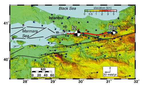
Figure 4. Topographic and simplified tectonic map (symbols as in Fig. 1) of Izmit- Duzce earthquake area showing epicenters and focal mechanisms (lower hemisphere "beachball" projections from Harvard CMT; larger is Izmit break, smaller is Duzce break), surface faulting (Izmit: heavy red line, dashed where inferred; Duzce: heavy blue line), pre-earthquake GPS-velocity field and 95% confidence ellipses, and GPS sites. Purple diamonds-continuous GPS stations operating prior to earthquakes; red squares-continuous GPS stations installed within two days of Izmit main shock; blue dots-survey-mode GPS sites observed less than two years prior to earthquakes and currently being reobserved to estimate coseismic motion. IB-Izmit Bay, HD-Hersek delta.